
The Benefits of Situational Awareness in Law Enforcement

A Skydio Dock for the X10, the launch and landing infrastructure behind a dock-based DFR program.
Law enforcement agencies make decisions in environments where conditions can change in seconds. A developing incident, a missing person, a public event, a natural disaster, or a threat to critical infrastructure can quickly involve multiple locations, teams, and agencies.
In these situations, situational awareness gives personnel the information needed to understand what is happening, assess what it means, and determine what may happen next. When situational awareness is supported by real-time mapping, connected communications, sensors, video, and uncrewed aerial systems, agencies gain a more complete operational picture, and a stronger foundation for faster, safer decisions.
For police departments, sheriff’s offices, fire departments, emergency services, and state and local governments, modern situational awareness is no longer limited to an individual officer’s immediate surroundings. It is an organization-wide capability that connects people, information, and resources across the response environment.
What Is Situational Awareness in Law Enforcement?
Situational awareness is the continuous process of perceiving relevant information, understanding its significance, and anticipating how conditions may develop.
In law enforcement, this may include:
- The location and status of officers, vehicles, and specialized units
- The location, severity, and progression of an incident
- Known hazards, restricted areas, and nearby critical infrastructure
- Live video, sensor, dispatch, and intelligence information
- Available resources from neighboring agencies or emergency services
- Potential impacts on residents, bystanders, and responding personnel
A modern geospatial situational awareness software platform brings these data points together through a shared, location-based operating picture. Instead of relying on disconnected systems or incomplete updates, command staff and field personnel can access relevant information in a format that supports action.
The result is better visibility, stronger coordination, and more informed decisions under pressure.
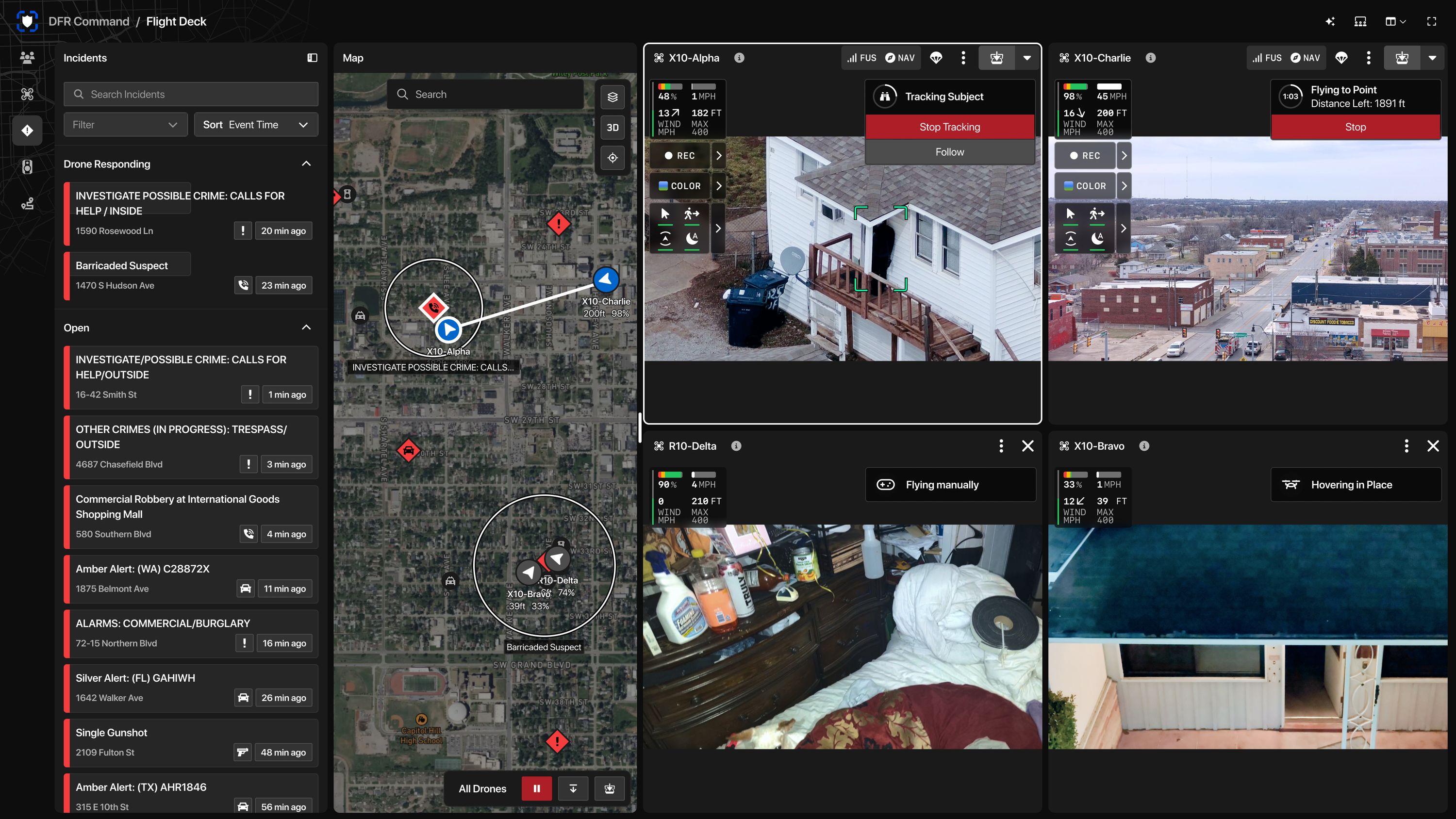
A DFR command interface, where incident calls, live aircraft video and mapping come together for the people making decisions.
1. Improved Officer Safety
Officer safety is one of the most important benefits of real-time situational awareness.
Responding personnel may enter environments with limited visibility, incomplete information, changing hazards, or conflicting reports. A shared operational picture helps officers understand the conditions around them before and during an incident.
Location-enabled systems can help agencies:
- Track the position of responding units and specialized teams
- Identify nearby officers and available backup
- Display hazardous areas, road closures, and restricted zones
- Share live video or aerial intelligence with field personnel
- Monitor changing conditions across a large or complex scene
- Reduce the risk of confusion between agencies or units
This information supports safer positioning and more deliberate tactical decisions. Officers can better understand where teammates are located, which routes are accessible, and what risks may exist beyond their immediate line of sight.
Technology does not replace training, judgment, or established procedures. It strengthens them by reducing uncertainty and making critical information available when it matters most.
2. Faster Response and Better Resource Allocation
Every response begins with a decision about where to send resources and how quickly they need to arrive. Real-time situational awareness helps dispatchers, supervisors, and command staff make those decisions with greater precision.
A geospatial platform can display incidents, units, routes, and relevant locations on a common map. This enables agencies to identify the closest available resources, adjust assignments as conditions change, and avoid sending personnel into areas affected by congestion or hazards.
For public safety agencies, this can support:
- Faster dispatch and deployment
- More accurate routing
- Better coverage during high-demand periods
- Improved management of special events and large gatherings
- More efficient use of specialized units
- Faster identification of gaps in operational coverage
The benefits extend beyond emergency response. Historical and real-time location data can help agencies evaluate deployment strategies, understand recurring patterns, and plan staffing for events or areas with elevated service demands.
When information is organized around location, decision-makers gain a clearer understanding of how an incident affects the wider environment, not just a single address.
3. Stronger Coordination Across Agencies
Major incidents rarely remain within the boundaries of one department. Police, fire, emergency medical services, transportation officials, public works teams, emergency management personnel, and state or federal partners may all contribute to the response.
Without a shared operating picture, agencies can work from different information, duplicate efforts, or miss important developments. Integrated public safety communication systems help establish a common framework for coordination.
Real-time situational awareness can help agencies:
- Share incident locations and operational updates
- Coordinate resources across jurisdictional boundaries
- Provide consistent information to field teams
- Establish common perimeters and evacuation zones
- Manage mutual-aid resources more effectively
- Support unified command during complex incidents
This coordination is especially valuable during severe weather, public demonstrations, active threats, search-and-rescue operations, wildfires, hazardous-material events, and other incidents that require multiple disciplines.
A connected response improves continuity. Personnel can act on the same information while maintaining the communications and procedures required by their respective agencies.

4. Better Evidence, Documentation, and Accountability
Situational awareness technology can also strengthen the record of an incident.
Time-stamped location data, dispatch information, video, sensor readings, and operational updates can help agencies reconstruct what occurred. This supports after-action reviews, investigations, training, reporting, and accountability.
A well-designed system may help agencies document:
- When units were dispatched and where they traveled
- Which resources were assigned to an incident
- How conditions changed over time
- What information was available to decision-makers
- How agencies coordinated during the response
- Where personnel, vehicles, and equipment were located
This creates a more complete operational record than narrative reports alone. It can help supervisors identify lessons learned, improve standard operating procedures, and evaluate whether resources were deployed effectively.
Technology must be implemented with appropriate access controls, retention policies, privacy safeguards, and cybersecurity protections. When those requirements are built into the solution, agencies can improve documentation without compromising the security or integrity of sensitive information.
5. More Effective Use of Drones and Uncrewed Systems
Drones and other uncrewed aerial systems can provide valuable visibility in environments that are difficult, dangerous, or time-consuming for personnel to access.
During a search, perimeter operation, disaster response, or critical infrastructure assessment, aerial intelligence can help teams understand terrain, identify hazards, monitor movement, and support decision-making from a safer distance.
When integrated into a broader situational awareness framework, drone data can be shared with authorized personnel in the command center and in the field. This makes aerial information part of the operational picture rather than an isolated feed viewed by only one operator.

The operator's view in the Skydio flight interface: live mapping, flight telemetry and a thermal camera feed of a structure fire shown alongside the colour view.
Potential applications include:
- Search-and-rescue operations
- Missing-person investigations
- Large-event monitoring
- Traffic and roadway incident management
- Disaster assessment
- Perimeter and facility security
- Support for fire and emergency response
Grace3 Technologies supports public sector organizations through technology domains that include Geospatial & Situational Awareness, Public Safety, Connectivity and 5G, Cybersecurity, and Autonomy & Robotics. This cross-domain approach helps agencies evaluate what a drone as first responder program is, how agencies fund it, and how DFR video holds up in court as drones, communications, mapping, and security systems work together.
6. Increased Protection for Critical Infrastructure
Police and public safety agencies often support the protection of transportation networks, utilities, campuses, government facilities, communications sites, and other essential assets.
Situational awareness improves visibility across these environments. By combining geospatial data, access information, cameras, sensors, communications, and response workflows, agencies can identify developing issues and coordinate the appropriate resources.
This supports broader critical infrastructure security solutions by helping agencies:
- Monitor sensitive locations and surrounding areas
- Identify unusual activity or emerging hazards
- Coordinate response with facility operators
- Maintain visibility during outages or disruptions
- Support continuity of operations
- Protect public services and community access
The same capabilities can support both routine monitoring and high-consequence incidents. Agencies gain a flexible foundation for managing daily operations while remaining prepared for larger events.
7. Greater Community Trust Through Better Service
Community trust depends on effective, consistent, and accountable public safety operations. Situational awareness technology contributes by helping agencies respond with greater context and precision.
When personnel have a clearer understanding of an incident, they are better positioned to assess the situation, communicate effectively, and select a proportionate response. Better information can support de-escalation, reduce preventable confusion, and improve service delivery.
Situational awareness can also support transparency through stronger documentation and more consistent reporting. Agencies can use operational data to evaluate performance, identify service gaps, and communicate how resources are being used.
Technology alone does not create trust. Trust is built through policy, leadership, training, community engagement, and responsible implementation. However, dependable information systems give agencies a stronger foundation for delivering the level of service communities expect.
Building a More Connected Public Safety Operation
The benefits of situational awareness extend across the entire public safety mission:
- Officer safety: Better visibility into personnel, hazards, and changing conditions
- Faster response: More accurate deployment, routing, and resource allocation
- Agency coordination: A shared operational picture across jurisdictions and disciplines
- Evidence and accountability: Stronger documentation of incidents and decisions
- Operational resilience: Improved readiness for emergencies and infrastructure disruptions
- Community confidence: More informed, consistent, and proportionate service
Grace3 Technologies works with U.S. public sector agencies and their technology partners to deliver customized, mission-critical IT solutions. Our ecosystem includes vendors, resellers, system integrators, and aggregators supporting public safety, critical infrastructure, connectivity, cybersecurity, geospatial intelligence, and emerging technologies.
We also simplify the path from mission requirement to solution. With access to a documented portfolio of 15 contract vehicles and a procurement team that can deliver quotes in 45 minutes or less, Grace3 helps agencies move from planning to execution with greater speed and confidence.
Situational awareness is the foundation for informed action. With the right technology partner, police, sheriff, fire, and emergency services agencies can strengthen that foundation, and advance public safety with greater speed, coordination, and operational confidence.
Explore Grace3 Technologies’ solutions for public sector agencies or contact our team to discuss a customized approach.